


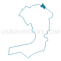
Voting District 2600014, Queens County, New York
About
Outline

Summary
| Unique Area Identifier | 635233 |
| Name | Voting District 2600014 |
| County | Queens County |
| State | New York |
| Area (square miles) | 2.04 |
| Land Area (square miles) | 0.27 |
| Water Area (square miles) | 1.76 |
| % of Land Area | 13.46 |
| % of Water Area | 86.54 |
| Latitude of the Internal Point | 40.79374780 |
| Longtitude of the Internal Point | -73.77532440 |
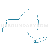
Maps

Graphs
Select a template below for downloading or customizing gragh for Voting District 2600014, Queens County, New York


Neighbors
Neighoring Voting District (by Name) Neighboring Voting District on the Map
- Voting District 0416036, Nassau County, NY
- Voting District 2600013, Queens County, NY
- Voting District 2600023 2600025 2600026 2600031, Queens County, NY
- Voting District 2600053, Queens County, NY
- Voting District 2600067, Queens County, NY
- Voting District 2600100, Queens County, NY
- Voting District 8200002, Bronx County, NY
- Voting District 8200005 8200041, Bronx County, NY
Top 10 Neighboring County Subdivision (by Population) Neighboring County Subdivision on the Map
- Queens borough, Queens County, NY (2,230,722)
- Bronx borough, Bronx County, NY (1,385,108)
- North Hempstead town, Nassau County, NY (226,322)
Top 10 Neighboring Place (by Population) Neighboring Place on the Map
Top 10 Neighboring Unified School District (by Population) Neighboring Unified School District on the Map
- New York City Department Of Education, NY (8,175,133)
- Great Neck Union Free School District, NY (44,580)
Top 10 Neighboring State Legislative District Lower Chamber (by Population) Neighboring State Legislative District Lower Chamber on the Map
- Assembly District 16, NY (134,747)
- Assembly District 82, NY (125,736)
- Assembly District 26, NY (123,681)
Top 10 Neighboring State Legislative District Upper Chamber (by Population) Neighboring State Legislative District Upper Chamber on the Map
- State Senate District 16, NY (322,463)
- State Senate District 11, NY (320,102)
- State Senate District 34, NY (315,408)
- State Senate District 7, NY (311,141)
Top 10 Neighboring 111th Congressional District (by Population) Neighboring 111th Congressional District on the Map
Top 10 Neighboring Census Tract (by Population) Neighboring Census Tract on the Map
- Census Tract 991, Queens County, NY (6,507)
- Census Tract 3005, Nassau County, NY (5,485)
- Census Tract 118, Bronx County, NY (5,089)
- Census Tract 3001, Nassau County, NY (5,010)
- Census Tract 997.03, Queens County, NY (3,892)
- Census Tract 138, Bronx County, NY (3,042)
- Census Tract 1093, Queens County, NY (3,034)
- Census Tract 1483, Queens County, NY (2,863)
- Census Tract 997.05, Queens County, NY (2,632)
- Census Tract 999, Queens County, NY (0)